How Do You Forecast Storms?
This is the question I get asked the most, and this is what this guide is for! To help give an overview on how to forecast storms. The second most frequently asked question is "what is the best way?" Well, a lot of people don't like the answer I give - because the "best way" is not really the easiest way! And few people believe me when I tell them, but here's (in my opinion) the "best way" to forecast storms!
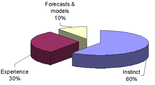
This may give a bit of a shock - only 10% for forecasts and models! Yet chances are, people (including myself) will still look at them fairly extensively. The thing is, computers can't think! We can, and we're lucky enough to be able to learn things. Instinct is so important! How does the day look? Feel? Smell even!? Or if the day(s) in question haven't arrived yet, how are the days before feeling and looking? There's a certain "feel" when it comes to thunderstorms (and all aspects of weather) - some days don't quite feel right, even though the models look great! Sometimes days feel great, even though he models don't look that crash hot - yet time after time, your feeling will often win ahead of the models. Experience and instinct work hand in hand - you develop your gut feeling and instinct by experience, by learning things it helps you get a better feel for what's happening around you. Hence, I often lump them in together and think that 90% of storm forecasting really is instinct and experience! So don't be afraid to listen to your gut feeling - trust it further and you might be surprised about how much you already know. Learning about weather is not something you can read in a guide or read in a book - it's something that you need to learn and "nurture" so to speak. So this guide is not going to teach you all there is to know about storms (and first and foremost, that's because I don't know everything there is to know about storms - only a small part in an endless tangle of web!) But I hope that it helps people have a better understanding of what they're looking at so that they may gather more experience and develop their gut feeling and instinct better. The other aim of this is to help teach people exactly what some of the thunderstorm indicies do. While it's nice to look at a LI chart and see nice big splotch of -6 over you, what does it really mean? We know it's "good" - but what else? It reminds me somewhat of going into a computer store and a salesperson is trying to sell a computer. They ratter off lots of impressive specs, and all they know is "that's good" - but they don't know why it's good, or perhaps it's going to give them something they don't really need or want. Think about it - if you know what you're looking at, then perhaps you might be able to choose the "specifications" of your thunderstorm too! Do you want lightning? Structure? Hail? A tornado? Or do you just want any thunderstorm? Knowing what you're looking at can certainly help you decide which type of storm you're after! It's all very nice having a DVD player on the computer, but is it worth sacrificing that CD writer that you really want? This is why it's important to know what you're looking at, as opposed to just knowing "that's good!" So in brief...look at the data to give you an idea, then let your senses guide you...
|