Introduction to Forecasting Thunderstorms We've established that we need instability as one of our essentials to thunderstorm development. But how do we measure instability? There's a few ways. The best way is to open a Skew-T and look, but for the moment it will be easier to use a few other methods. And these methods generally work well too - especially on a broad scale, I often look at things on a broad scale before going back in for a closer look with a few Skew-Ts and other information. One of the most popular ways of deriving instability is using the lifted index (LI). So what is it? Well, basically - if you ascended a parcel of air at the surface and then compared it to the actual environmental temperature at the 500mb level of the atmosphere (approximately 18,000ft), then that gives you your LI! Quite simple really, and quite a good little way of deriving instability. The actual formula if you're interested is: LI = Environmental temperature - temperature of ascending parcel So lets say our environmental temperature was -15C, and the temperature of our ascending parcel is -5C, then: LI = -15 - 5 LI = -10 Ok...so our LI is -10C, that's great!
Right? Err...what does it mean? Well...as a guide I tend to
think of the LI as potential as opposed to what will and won't happen.
Keep in mind that these "magic numbers" assume that other things are adequate
(eg, trigger for storms, shear and other factors for severe storms).:
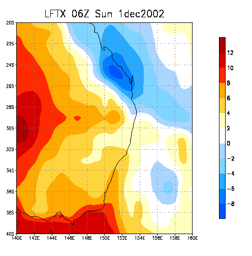
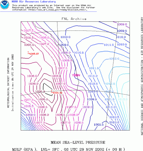
One thing quite a few people do is load the LI and then see if it's nicely negative or horrendously positive and then immediately say yay or nay to storms for that area. To be honest, quite a few times you're going to be right - the LI is certainly a very good index for instability! But also remember that there's a lot more to just looking at the LI, and if you want to become more accurate you'll need to look at other things than the LI, such as CAPE, or better still - Skew-Ts! Also remember something else - the LI only tells you if one level is unstable! Think about it...what if the 500mb level instability is not representitive of the remainder of the instability in the atmosphere? We could have a warm layer at 500mb, so the LI is quite high, or we could have a cold layer at 500mb so the LI is quite low (ie strongly negative). Where can you find LI forecasts? There's a few models that do it, it's a case of personal preference, but I use AVN when I look at LIs. Select the latest forecast set, then choose "LFTX," and then select your date and time (time is in UTC, add 10hrs for EST, 8hrs for WST). After some experience you can fiddle around with the contour interval, and perhaps even pull out a map of your area and look at zooming in using the custom option! I use 140, 20, -40, 20 respectively in the four longitude/latitude boxes and that gives me the southern half of Queensland and most of NSW. A few last thoughts about the LI though...lets look at an LI chart...
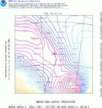
Wowzers! Some nice -8 to -10 LIs over Capricornia - lets head to the middle of it, right! Right...? Right??? Hmmm...lets have a think about it first. If we ignore shear (read about that here), and assume that our other main thunderstorm features are shear and cap, and they're all equal over the area. Would we really want to head to the LI bullseye? Why does the LI increase so quickly when you shift to the west? Is it because of an upper trough? Well, lets look at our 500mb temperatures and see...
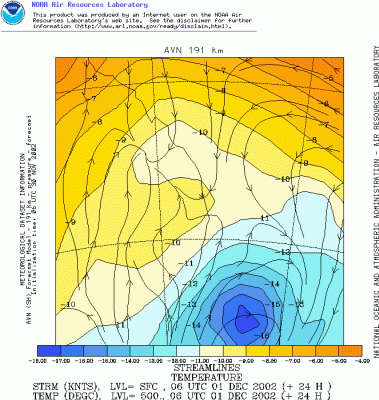
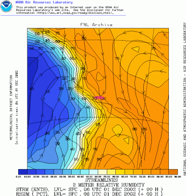
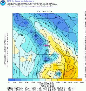
Ok, this is a good way of looking at things - 500mb temperatures are a great little way of checking on our LIs to see what they're doing, are they decreasing because there's an extremely sharp and cold upper level cold cool, or is it because of large amounts of heat and moisture? Well, we've also overlaid the surface streamlines here, so we can automatically see two things! First, yes there is an upper trough (a quite nice one too, we're in Capricornia here which is the southern edge of the tropics, so -10C @ 500mb is quite considerable!) A good way to see the strength is compare the temperature in that area, against other areas of the same latitude. You can see that if you drift E or W you'd run into -7C 500mb temperatures, so that's not too bad (again, this is the southern tropics now!) But the upper level trough isn't that sharp, and certainly not enough to cause our LIs to increase rapidly into the positives as we drift was of the LI max. What about heat and moisture? Well, I'm going to concentrate on moisture here, and if you take the chance to read about Skew-Ts, then you'll see what I mean about how much moisture can effect the LI! Look at the winds, lovely northerly winds coming straight off the tropical Coral Sea meeting a trough (line of convergence and where the streamlines meet), where we have southerly winds. Those southerly winds have traveled 1000s of kilometres over land! So while they may not be very cool, they're certainly going to be very dry! Unfortunately there are no "pure" dewpoint maps for Australia, you have to convert them from specific humidity. What's that you might ask? Probably best not to introduce it at this stage, it will get too confusing. But the other way you can look at surface moisture is actually using surface relative humidity (this has some limitations, but it's good enough for the descriptive purpose here). So lets look at a map...
Ok then! We can see a lovely tongue of moisture right along the coast - but look what happens once you cross that trough and push into those southerlies - the humidity plummets! Right, well since surface moisture is a critical thing to LIs, we've deducted one critical thing - once we hit the LI max, it's going to dry out and stabilise rapidly after. We also know that the LI max is very close to the trough, so things may very well initiate there first. But do you really want to sit underneath the trough line? You can't really see what's happening! It's personal preference, but I like to sit a little ahead of the trough line so I can take into account what's happening. The other thing you will want to take note of is how will thunderstorms move? More about how to decide where they will move in later sections. But on this day, storms were likely to move E or NE, so it would make sense to sit E or NE of the troughline so that you are ahead of the storms and don't get left behind. When it comes to storms though, I like being on the northern edge of them too - that's the most interesting part and where you can see most of the structure (not to mention a tornado if one develops!) Ok, so we have learnt some things about the LI. Don't always rush for the LI max, but we want strongly negative values ideally. We'll learn a bit more about the limitations of the LI later if you keep reading. I'll also talk about other factors - ie if we want strong or severe thunderstorms, instability and the LI aren't anything. First, one of the limitations of the LI that I mentioned before! The LI only tells us if one level is unstable. Is there another way of knowing if other levels are unstable (short of opening a Skew-T diagram). Yes there is! It's called CAPE (Convective Available Potential Energy). It's another very common and popular way of forecasting instability potential for thunderstorms. However I'm not going to explain it...yet - I think to really understand CAPE you need to know what a Skew-T looks like. So we'll continue onto a few other aspects of storm development first before going onto CAPE! Triggers Ok, so next we need a trigger. As mentioned in our thunderstorm ingredients before, triggers are needed to initiate thunderstorm development! Triggers include: - Troughs
All three are relatively common in Australia, especially with the ranges along the east coast (and often cause the first storms to develop on storm days). Although troughs can be a little more favourable than cold fronts (unless in the higher latitudes of the southern states), as cold fronts have a tendency to dry out a little further north (probably more so a concern because the air isn't as cold in the upper levels which enhances instability). Cold fronts can easily be identified from a wind change bringing significantly cooler temperatures (eg, NW winds swinging to the SW and dropping the temperature rapidly) - this is fairly common in states like Victoria and South Australia. SW'ly winds tend to dry out and warm as they travel across several thousand kilometres of land though, so they are not always that favourable (more so if the SW'ly change is a gusty one) - as I said, they can dry out the situation. But some excellent storm situations have developed in those situations! A more typical situation though is to have a pre-frontal trough (ie a trough ahead of the front). An example of this (not the best example in the world, if I see another one I will swap it over!) is listed below, with a weak front behind a pre-frontal trough - the pre-frontal trough an 800km long squall line developed bringing widespread damage to some of the northern inland NSW communities.
There are two points of interest here, the first is the pre-frontal trough - this can be seen just to the left of the middle, here NNE and NNW winds converging in the centre, signifying the trough. These winds meet at the centre, and collide. There is nowhere for the air to go but up, so that helps force the air upwards and can help break any cap that might be suppressing the convection. Further to the west, there is a wind change and the winds suddenly get a lot stronger. They swing around from the NW to the SW and increase in speed from the SW. This is the remnants of a weakening cold front, although the cold front itself is just another trough! To extent, this cold front is so weak it's almost just a trough by itself, so the trough ahead is almost a "pre-trough trough" instead of a pre-frontal trough! Troughs are essentially elongated areas of low pressure and can be seen either on streamlines or using pressure charts. Streamlines are probably a good way to see boundaries (especially now that there are higher resolution models such as FNL that offer more detail now - it seems to have had a revamp from recent years (previously AVN), it even seems to pick up things like seabreezes on the Australian coast, where as previously it never did). To see the same thing, you can look at BoM charts or the same model will also give you analysis/forecast pressure charts.
You can pick the main trough/weak cold front on this quite well - but you can't really see the pre-frontal trough. So that's where streamlines can be handy - but don't use them as law! Often if you look at the satellite images you can see where the boundaries are and would be more accurate than streamlines. I like streamlines as they do give you a good guide where the main boundaries will lie for storm development - but don't use them as law! Obviously sometimes you only have the one boundary (ie just a trough), for instance, the following day has just a trough along the coast and that was pretty much picked by streamlines and the pressure!
Another great way if the boundaries aren't showing on the satellite images though is to look at the observations around the place. If you're not up to scratch on your geography - a road atlas could be handy to help you put things into perspective. Say the SE QLD area all has NE'lies, but in NE NSW everywhere by the northern most observation station (Byron Bay) as SE'lies, then you know that there's a boundary/trough just south of Byron Bay. If it extends inland, you might be able to pick up the trough by changes on the Northern Tablelands and Darling Downs too (eg, Warwick might have N'lies but Stanthorpe could be reporting a SE'ly). One little note - sometimes when it's quite warm, a weak SE change may push up the coast. But it will lag inland - these can be prime storm areas! The October 9 supercell was testimony to this! Ok - so there we have it, we know how to make a thunderstorm using instability (heat, moisture, relatively cooler air aloft), and a trigger! What about severe thunderstorms? That's a little more involved... |