Severe Thunderstorms in Low
Shear
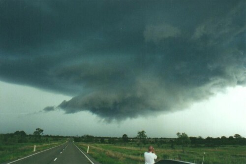
One of the favourite supercells that I chased was the November 21, 2000 Banana Supercell. A horrible name! But it was quite memorable - one of the best wall clouds that I've seen and some of the most defined rotation that I've seen too. In fact, you would have thought this was a day of plenty of shear...here's the wall cloud I mentioned:
And once again I encourage you to check out the chase report on this day to get an overview for the situation! This supercell moved nearly parrallel with the highway (seen in the photo - that's a major Australian highway I might add!) so it was good chasing. The other thing is, the storm developed in a higher region (ie around 400-500m high), and as we learnt before...this increases the instability in the area. But first, lets look at the shear - keep in mind the shear on this day really wasn't that bad at all. But for strong rotation, you often expect good shear - especially in the low levels, but that didn't happen...so lets analyse why we got we we got!
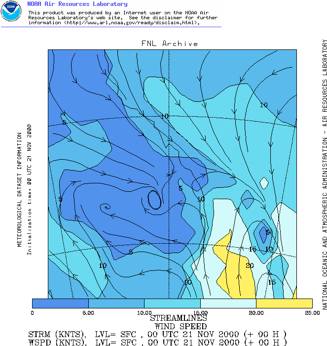
Where's Banana you ask? (It's not exactly a major location...) well, it's NW of Brisbane...I decided to plot these maps with Banana in the middle (so Banana is the asterix). The storm started about 40-50km SW of Banana though. Note one other thing...I've used 00z maps instead of 06z maps. That's because the main storm was early in the afternoon (1-2pm, or 3-4z), yes 06z is closer but looking at this, I think that the 00z maps give a better representation of what was happening in the area. (In case you're wonder, 06z shear is a lot weaker than 00z shear! So we could probably deduct some wind strength off the speeds...but we won't). Here we can see a (poor) NW'ly flow just north of a low. There was plenty of moisture due to widespread storm activity over the last week over western Queensland, so the NW'lies were of no concern. The low was moving quite quickly northwards, and was bringing with it a SE'ly change...one thing that I feel is that the Banana supercell "rode" the SE'ly change north - this would certainly have added another uplift point for confluence and also given additional directional shear!
We can see here that the directional shear here is quite good...straight away it's gone to 5-10 knots from the WSW! (Speed shear is bad <poor to marginal>...directional shear is good...well it's something!)
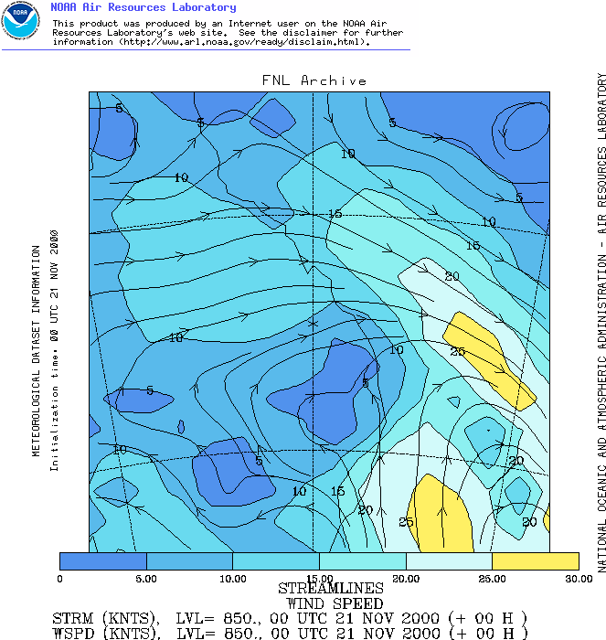
700 winds are OK here...around 15 knots (marginal) (remember, to the SW of Banana...and the shear is weakening over time). Still from the WSW too.
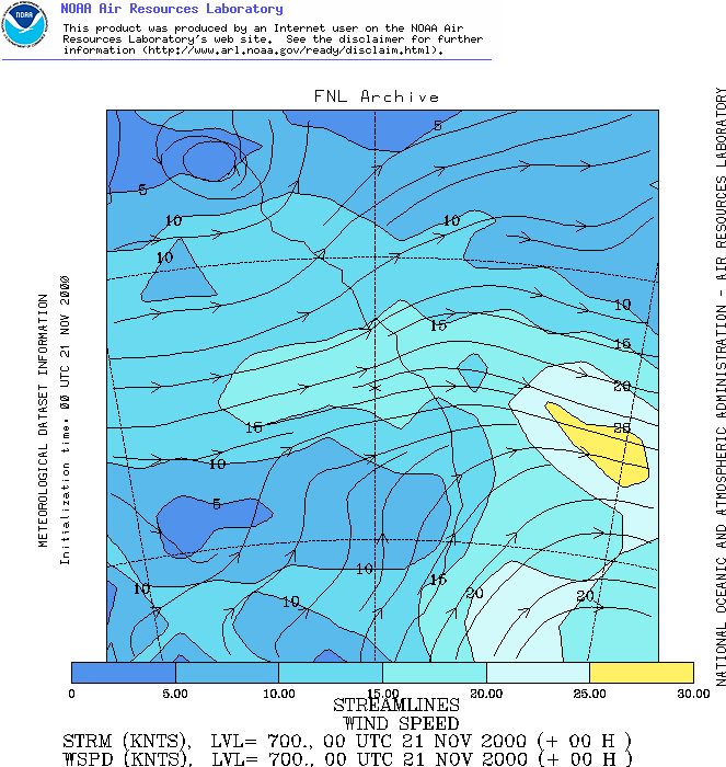
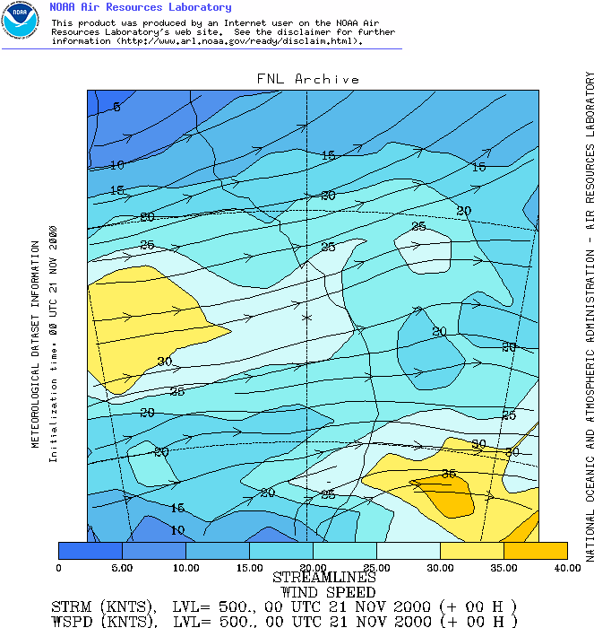
Here we have 25 knots @ 500mb from the WSW (adequate). We also had <5 knot NW'lies and then there were SE'lies pushing from behind it. However, do the maths and you'll see we're not going to reach our 40 knot 0-6km supercell threshold! In fact we're going to struggle to reach 30 knots in the 0-6km threshold...yet still we can see that we had supercells! Lets keep going...
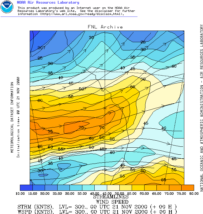
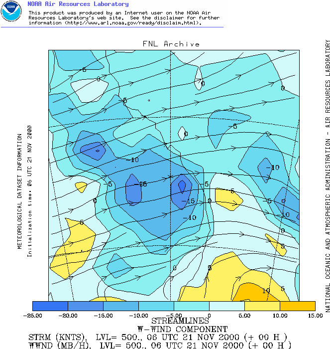
Alright at 300mb!!! Too bad this was weakening during the day...but here we see around 65-70 knots (good) at 300mb. One other thing I want to show...both the 500 and 300 jets were in the process of becoming diffluence, so I'm going to show the 06z VVs of these two levels to see how much the air was rising. At 00z, these values were 0 to -5. First 500...
And 300...
Not bad! We can see that due to a weak upper trough pushing into the region (allowing the air to rise), and the help of some diffluence we have some vertical upmotion happening, so this is going to enhance our instability. But before we look at the instability (the key on this day), lets re-assess our shear categories. I'm going to purposely apply the techniques from certainl thresholds. The reason why is to prove that they don't always work if you use them this way, they're meant as a guide...not as strict rules!) Surface - poor (1)
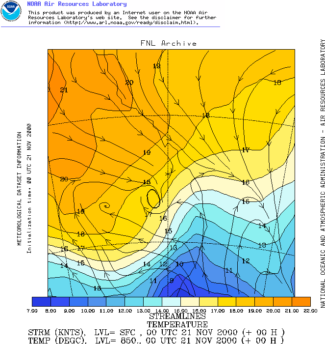
Total rating: 2.3 (marginal) Our shear rating really isn't all that good...it's not horrible, but we could do a lot better in the shear ratings! Alright, so lets look at some other things...given shear isn't everything. But remember our cap didn't do us any favours (storms were roaring along not long after 11am...so the cap was quite weak). No surprise why when you look at the 850 temps either...
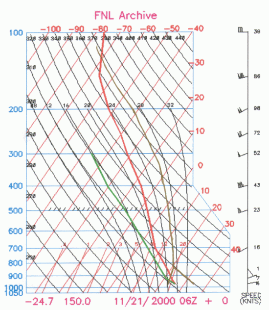
Storms started well south of that location and you can see cold air at 850 pushing into the region weakening the cap. One thing we haven't looked at is the instability. Keep in mind that we had nearly a week of storms...DPs were sky-high! In the low-mid 20s, and there was a very moist slab of air at the surface which was well mixed. Furthermore, temperatures quickly reached into the 30s by late morning...and we also had some elevated heating. So you might have already guessed we're going to have some nice instability...so lets look at a sounding!
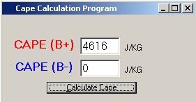
Wowzers!!! That's some instabilty there!!! LIs of around -9 to -10...and CAPE of...
4600!!! The atmosphere is massively unstable! And this was the key to this day...we had marginal shear, but we had absolutely awesome instability. That allowed for severe storms to develop (and this supercell)...this is just one example of how the "tradeoff" can work, and how you have to look at the overall picture, not just a few things! I'll continue on now with some even "more marginal" situations... |