Severe Thunderstorms in Low
Shear
We've just seen a great example of how instability can help offset shear. This is another example...no supercells on this day, but some roads were closed in the Brisbane Valley/Wide Bay region from trees over them! So certainly no shortage of severe weather. The day was forecast and also analysed very poorly from models...the models grossly underforecasted moisture (hence the forecast was for -1 LIs!) But there was plenty of moisture with a fairly thick moist layer too as a deep easterly flow developed. Once again we'll look at shear and give them ratings like before to proove the ratings incorrect! Oh, before a quick snapshot of what happened. Check out the chase report of this day...for us, the best stuff was photogenic really. But notice the powerful updrafts? We can already see that the real LIs were not -1 on this day!
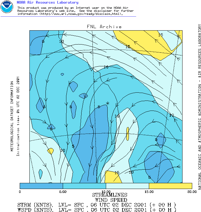
Ok...surface flow!
We're off to an OK start...5-10 knots puts it in our marginal range...but so often I see weak winds at the surface for storm events (which is unfortunate). You can see the exstensive northerlies coming off the Coral Sea too...so plenty of moisture at the surface!
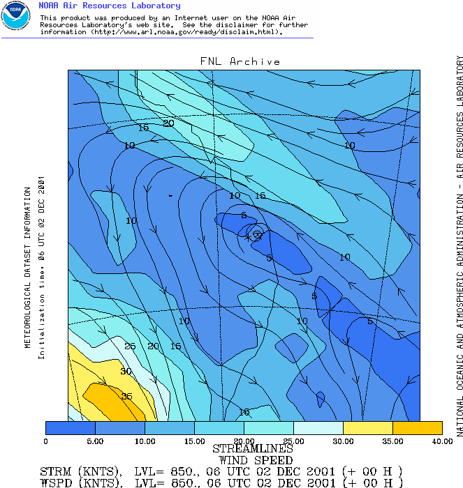
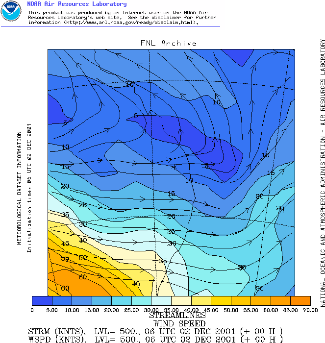
850mb doesn't really strengthen at all...we hover around the same 5-10 knots (poor-marginal)...once again we can see that we have extensive northerlies with the origin over the Coral Sea...hence our backing for a deep moist layer (also it was very visible by the amount of low level cu early in the day). Note the anticyclonic rotation over the Wide Bay area? (Asterix)...hmmm...I normally associate that with fairly warm 850 levels, lets have a quick squiz at the 850 temps!
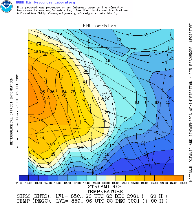
That's not too bad...850 temps of around 20C, so the cap is fairly strong, but it could be broken. Development on the Downs was during the afternoon...but the main Wide Bay development exploded late in the afternoon after 4pm...here we see that the cap held the convection until late in the day when it was able to release all of the energy! Had the cap broken earlier, then things may have become cluttered (they sometimes can in low cap, low shear, high instability situations - but not always as before in the previous example). Lets look at 700mb to see if shears gets any better there!
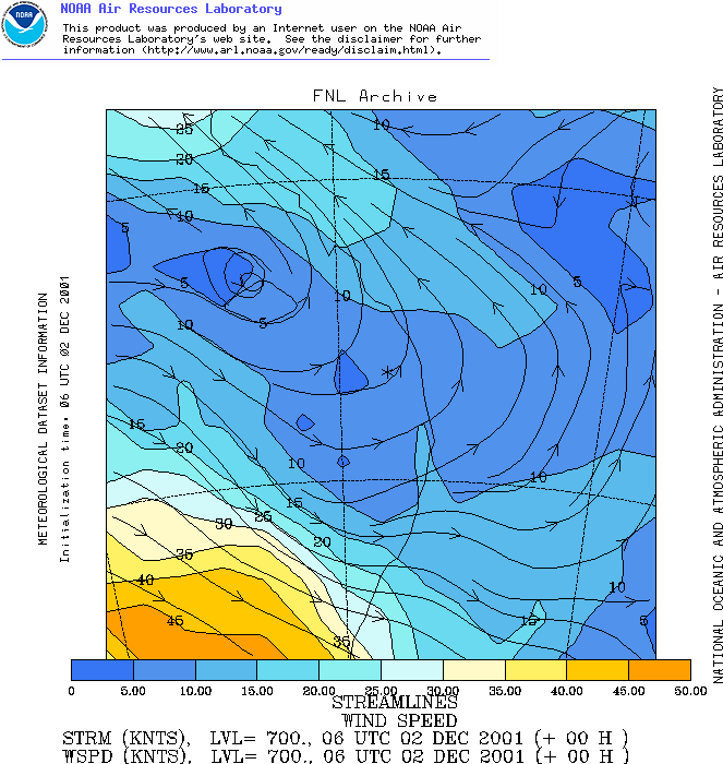
Urk! This is clearly not looking good for shear, 5-10 knots (poor) at 700! What about 500 and 300...
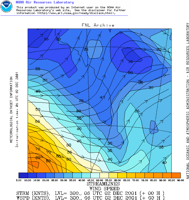
No good really...500 is 10-15 knots (poor) and 300 is 20-25 knots (marginal). We do have some good directional shear though...turning from the NNE towards the W in the lower 6km which is something! But really, shear is bad...again, lets look at the cutoffs in strict terms: Surface - marginal (2)
Total: 1.5 (poor-marginal) We can't even attain marginal status here! What hope do we have of severe storms you might ask? Well they still happened! Once again, lets look at a Skew-T and plot some instability...I've adjusted for maximum potential on the day with a much deeper PBL than was analysed (to something more accurate).
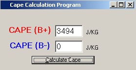
Some nice instability once more! Sure, not as much as Banana, but lets look at CAPE, it's bound to be impressive again!
Nearly 3500!!! That's still some awesome instability! The instability and the strong cap is what helped develop severe storms on this day despite the absoutely horrible shear! Another example where in theory severe storms shouldn't have happened but they did! So lets look into a different type of setup...what about lots of shear and little instability? |